Protection and enforcement
Maritime heritage not only provides us with tangible remains, but also with stories from the past. These provide valuable knowledge and important insights into moments in the maritime history of the Netherlands and other countries. Without responsible management, wrecks disappear, or their artefacts and construction materials are looted. The Cultural Heritage Agency of the Netherlands (RCE) works closely together with partners in the Netherlands and other countries to protect shipwrecks by developing tools to gather evidence of wrongdoing.
International and national laws protect shipwrecks from looting and other disturbances. However, it is difficult to get conclusive evidence in order to enforce these laws. We are dealing with huge areas, often far from any form of direct supervision. Especially in the case of shipwrecks located outside of Dutch waters, the threat is serious. This is evidenced, for example, by the illegal salvage of warships in Southeast Asia, such as the Dutch submarines in Malaysia and the three Dutch warships from the Battle of the Java Sea. To increase the chances of catching and/or convicting the perpetrators, the RCE works closely together with various partners on the chain that should lead to conclusive evidence. Creating an effective chain requires a lot of consultation and the development of new methods. Below we describe two such methods that have been specifically devised within the framework of the International Programme for Maritime Heritage.
Forensic marking
The illegal, large-scale salvage of World War II ships accelerated the search for better methods of enforcement. There was great public outcry over the disturbance and destruction of these wrecks and the desecration of war graves. The programme, together with its UK counterpart Historic England, commissioned maritime company MSDS Marine to research methods of marking metal objects underwater. In developing these, the three organisations work closely together. The starting point was that the methods to be developed could be used not only for warships from both world wars, but also, for example, for (bronze) cannons on much older ships.
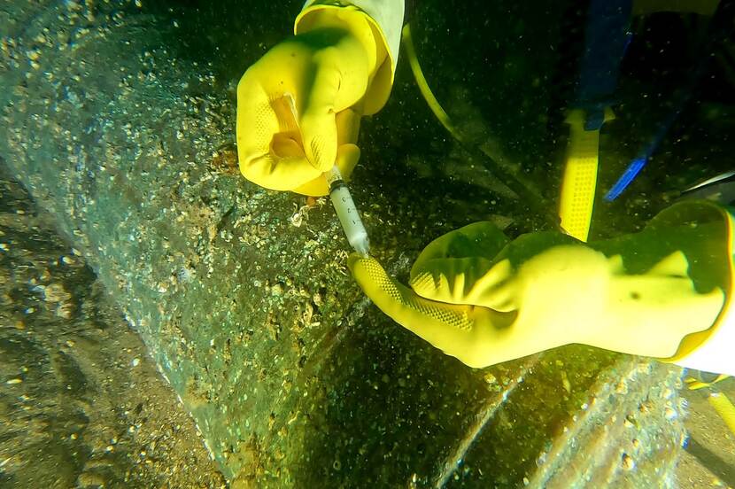
In 2023, we have started marking shipwrecks, amongst which the wreck of the Klein Hollandia. The material used to mark the objects remains even after rinsing and even spreads over the people handling the object, over the deck and any drains where the rinsed water ends up. A veritable nightmare, therefore, for trespassers. Upon discovery, the material can be read to identify exactly which wreck the object came from. These markers have been tested for environmental contamination and applicability in nature.
Satellite monitoring
It is becoming increasingly easy to visit shipwrecks. Even the deepest and most remote places on earth can be reached. Especially with World War II wrecks, the pressure is very high, in Asia as well as in South America and Europe. After all, low-radiation iron fetches a lot on the market. Detection and enforcement of these mostly illegal activities are therefore a high priority in the management chain of Dutch shipwrecks abroad. Therefore, tests are also being carried out on how wrecks can be monitored via satellites.
Monitoring shipwrecks underwater is one of the biggest challenges in underwater cultural heritage management. With the use of satellites, we do not need to be close by to still see what is happening at a site. Developing and testing the method involves collaboration with UK partners Maritime Archaeology Sea Trust (MAST), the international organisation OceanMind, the Dutch Ministry of Defence, the Dutch Information and Heritage Inspectorate and Dutch defence experts (MIVD). For the project, extensive analysis was done of the Automatic Identification System (AIS), transmission data and Visible Infrared Imaging Radiometer Suite (VIIRS) detections and a selection of 286 Synthetic Aperture Radar (SAR) and Electro-Optical (EO) images of the selected areas. For the tests, the partners used data from 2018 to 2020 for areas where shipwrecks lie in the Dutch, Belgian and English North Sea, as well as further afield at the locations of the Dutch WWII submarines in Malaysia. The main aim was to see which shipwrecks are threatened, and how. A secondary aim was to test available methods to monitor heritage and learn lessons from this, in order to inform governments on how to better manage their underwater heritage.
After this pilot phase, the implementation of the satellite monitoring will be taken over by the Information and Heritage Inspectorate (also part of the Ministry of Education, Culture and Science).