Pilot Maritime Observatory successfully monitored Dutch wreck sites at risk
The monitoring and protecting of valuable underwater heritage sites has been one of the greatest challenges for heritage and government institutions in the last decades. In a special pilot, British and Dutch partners have joined forces to initiate innovative research, using new technologies. The Maritime Observatory, a partnership between the Maritime Archaeology Sea Trust and OceanMind, was commissioned by the Cultural Heritage Agency of the Netherlands to lead this pilot.
Their research involved using satellite sources for the first time to monitor seven Dutch shipwrecks located in domestic waters and overseas in Belgium, UK, and Malaysia. The wrecks date between 1600AD and the Second World War and were monitored retrospectively for activity over a three-year period between 2018-2020. The aim is to better understand which sites are at risk globally and how they are threatened. This is important to enable (local) governments and authorities to take timely measures and collaborate on the protection of these vulnerable heritage sites.
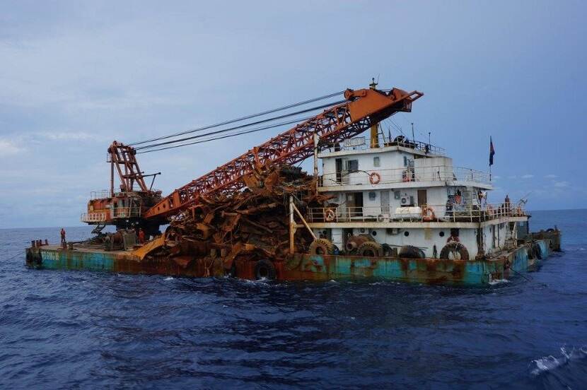
The pilot was able to identify multiple visits on several of the monitored sites with suspicious intention. That these visits can have an enormous impact on wrecks shows the near-complete destruction of two Dutch second world war submarine wrecks by unauthorized metal salvage in Malaysian waters and three other warships in the Java Sea. In European waters concerns were raised over the high-risk of accidental damage from fishing trawlers operating over wrecks and commercial vessels anchoring too close to protected sites in the North Sea.
What is the Maritime Observatory?
The Maritime Observatory (MO) has harnessed the growing capabilities of the commercial satellite sector to create a hub for monitoring the maritime and marine domain. Its purpose is to actively monitor and share information among relevant stakeholders, including government agencies, to protect wreck sites and deter illegal activity at sea. By combining archaeological expertise and specialist knowledge with advanced technologies, the MO enables effective monitoring, enforcement and compliance for the protection of maritime heritage sites and disseminates relevant information to the appropriate authorities.
“The use of satellite technologies, human and artificial intelligence to protect underwater cultural heritage and naval war graves is why the Maritime Observatory was established. We believe these methods represent the future for the protection of our nations’ common heritage,” Jessica Berry, MAST CEO, said.
Part of a management plan
For the Cultural Heritage Agency of the Netherlands, the satellite monitoring fits in a larger chain of activities that can provide useful information about the status and the condition of Dutch shipwrecks. Martijn Manders, Cultural Heritage Agency of the Netherlands, said: “We can only protect our underwater cultural heritage when we are willing to work together between countries and when we can provide information about illegal activities that is admissible in court.”
Wrecks are often found lying far away from the coast and vulnerable for many threats that easily remain unseen. It is therefore – amongst others - important to also set up alliances with national and international partners, creating priority lists for regular visits to sites under threat and creating national and international law and agreements that can be enforced.
Why act now?
Changes in technology now enable the detection and exploitation of previously undiscovered shipwrecks that were once protected by remoteness and depth. These once inaccessible sites are now at risk of unauthorized interference. Many such sites contain human remains and can also pose a danger to life and the ocean environment due to the presence of oil and/or unstable ordnance. The incidents reported in recent years show us that if we do not act now, especially the economically valuable sites will be lost forever.
See the website of Maritime Archeology Sea Trust for more information about this pilot.